A new study published in Built Heritage reconceptualizes the Historic Mosque City of Bagerhat in Bangladesh as an integrated hydro-cultural socio-ecological system, demonstrating that climate adaptation in this 15th-century settlement was structurally embedded within its urban morphology rather than implemented through reactive engineering. The research, conducted by Md. Reazul Hasan and Mokbul Morshed Ahmad, introduces the Hydro-Cultural Socio-Ecological System (HC-SES) framework to interpret resilience in deltaic heritage settlements. By combining spatial analysis, architectural morphometric assessment, and a dual-index evaluation model, the study reveals how hydraulic infrastructure, architectural forms, and governance structures operated as interdependent subsystems to moderate hydrological variability in a flood-prone estuarine landscape.
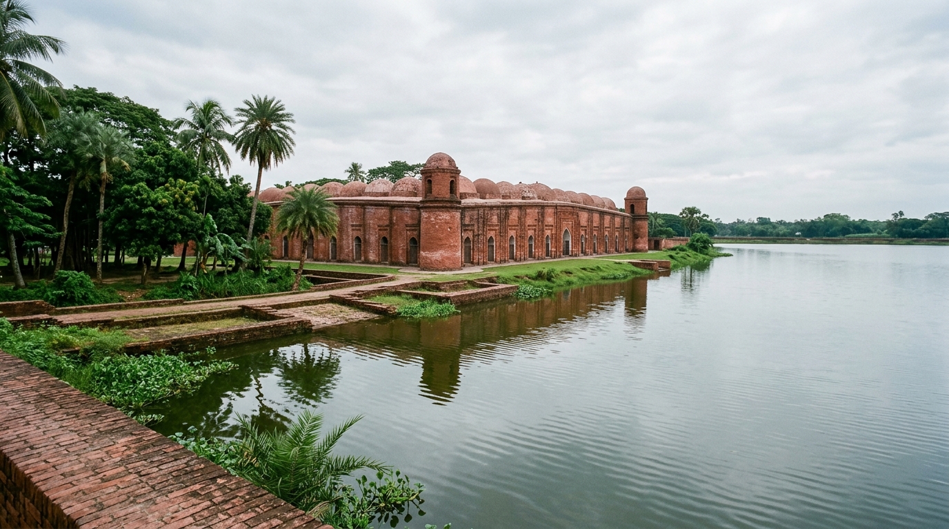
The Historic Mosque City of Bagerhat, a UNESCO World Heritage Site established in the 15th century under the governance of Khan Jahan Ali, presents a compelling case of coordinated environmental modification. Situated in the lower Ganges-Brahmaputra deltaic plain, the settlement developed within a monsoon-dominated environment characterized by seasonal waterlogging, high groundwater levels, and intense rainfall. The urban fabric integrates monumental congregational mosques, funerary complexes, and an extensive network of excavated reservoirs known as dighi. These reservoirs served multiple functions, including rainwater harvesting, groundwater stabilization, ritual use, and agricultural support.
To evaluate the adaptive capacity of this historic system, the researchers developed a dual-index evaluative framework comprising an Environmental Impact Index (EII) and a Sustainability Index (SI). This framework was operationalized through a two-round Delphi-Analytic Hierarchy Process involving thirty experts from fields including heritage conservation, architecture, hydrology, and disaster risk reduction. The consistency ratio improved from 0.12 in the first round to 0.09 in the second, indicating acceptable judgment consistency below the recommended threshold of 0.10. This methodological approach allowed for the transparent weighting of adaptation indicators, enabling a comparative assessment of vernacular strategies against modern engineered flood-control interventions.
The hydraulic subsystem analysis identified a multi-scalar hierarchy across six principal reservoirs, with surface areas ranging from 58.89 acres for Thakur Dighi to 1.24 acres for Mitha Pukur. Thakur Dighi functions as the primary hydraulic anchor, with an elevation range of 12.70 to 28.72 meters that significantly exceeds secondary reservoirs. This elevation difference supports the interpretation of excavation-derived mound formation adjacent to the Khan Jahan Mausoleum, suggesting that the excavation of the reservoir contributed to the artificial elevation of the surrounding land. Secondary reservoirs, such as Pocha and Ghora Dighi, range between 26 and 37 acres and appear to function as distributed runoff buffers within the broader settlement corridor, creating a nested, multi-scalar hierarchy of water management.
Architectural morphometric analysis focused on measurable elements associated with climatic performance, including wall thickness, cornice uplift, and plinth elevation. Of the eleven documented monuments, eight provided complete paired measurements and were included in the exploratory comparative analysis. The results indicated a weak positive association between wall thickness and cornice uplift, with an R-squared value of approximately 0.09. This suggests that while thicker masonry provides structural capacity for greater cornice articulation, the uplift geometry is not linearly determined by wall mass alone. Instead, the variation corresponds more closely to architectural typology, with monumental congregational mosques exhibiting pronounced curved cornices to enhance rapid monsoon runoff, while funerary structures prioritized vertical hydro-separation through mound elevation.
The socio-cultural subsystem was examined through archival documentation and spatial distribution patterns, revealing that governance intensity played a critical role in the settlement’s formation. Historical sources attribute large-scale reservoir excavation, land elevation, and mosque construction to coordinated patronage, implying organized labor mobilization and administrative oversight. The distribution of mosques along the approximately 6-kilometer east-west settlement corridor suggests a structured spatial organization, with monumental congregational mosques located at nodal positions adjacent to major reservoirs. This configuration indicates a hierarchical differentiation within the urban layout, where institutional coordination enabled large-scale environmental transformation and sustained long-term maintenance of hydraulic infrastructure through communal practices.
The dual-index evaluation demonstrated that most vernacular adaptation strategies in Bagerhat cluster within the high-sustainability and low-environmental-impact quadrant. This positioning reflects design principles rooted in landscape integration, material efficiency, and decentralized governance coordination. In contrast, modern engineered flood-control approaches tend to occupy positions with higher environmental impact values due to embodied material energy and long-term maintenance dependencies. Sensitivity testing, which involved a ±10% perturbation of indicator weights, produced no rank reversal among adaptation strategy clusters, with score variation remaining within ±6%. This indicates that the comparative positioning of strategies within the EII-SI analytical space is robust and not strongly dependent on specific weighting configurations.
The study highlights the concept of hydraulic architectural intelligence, defined as the embedding of environmental adaptation within built form. In Bagerhat, curved cornices facilitated rapid rainwater shedding during intense monsoon events, while thick masonry walls moderated thermal fluctuation and elevated plinths reduced flood vulnerability. These elements did not operate independently but in coordination with adjacent reservoirs that stabilized groundwater conditions. This integrated relationship between hydraulic systems and architectural morphology represents a hydro-cultural coupling where environmental control and symbolic expression coexisted, distinguishing the settlement from purely community-driven adaptation models by mobilizing traditional ecological knowledge at an urban scale under centralised authority.
Limitations of the study include the fact that reservoir measurements reflect present-day surface areas derived from GIS and field observation, which may not correspond precisely to historical extents due to sedimentation or later landscape modification. The morphological analysis is restricted to monuments with sufficient preservation and documentation, limiting the availability of complete paired measurements. Furthermore, the dual-index framework relies on expert-derived weights and context-specific indicator selection, meaning its evaluative outcomes reflect informed judgment rather than universal applicability. The statistical comparison between wall thickness and cornice uplift is exploratory in nature and should be interpreted as descriptive rather than inferential, given the limited sample size of eight paired observations.
The findings suggest that Bagerhat’s resilience emerged through the coordinated interaction of three subsystems: hierarchical reservoir infrastructure that moderated hydrological variability, climatically calibrated architectural forms that facilitated passive environmental regulation, and governance structures that sustained long-term infrastructural maintenance. By extending socio-ecological systems analysis into the domain of heritage urbanism, the HC-SES framework provides a structured method for evaluating adaptive capacity in historic cities. The study offers insights for climate-resilient heritage management in contemporary deltaic environments, suggesting that historically embedded adaptation strategies can inform modern planning frameworks through landscape-integrated water management and elevation-based settlement logic.
The study situates its findings within broader resilience scholarship, which has increasingly adopted socio-ecological systems perspectives to conceptualize adaptive capacity under climate stress. While contemporary discourse often prioritizes engineered adaptation measures and institutional governance frameworks, this research addresses a gap in how pre-modern settlements embedded adaptive logic within their spatial, hydraulic, and architectural configurations. The authors argue that historical scholarship has often treated architecture, water infrastructure, and governance as separate domains, whereas the Bagerhat case demonstrates these elements as components of an integrated socio-ecological configuration. By interpreting the city as a coupled hydro-architectural-governance system shaped by traditional ecological knowledge, the study moves beyond viewing historic settlements as static architectural artifacts and instead frames them as adaptive environmental systems.
Methodologically, the research employs a mixed-method, case-based analytical design that integrates spatial measurement, architectural morphometric analysis, and a dual-index evaluation framework. Rather than testing predictive hypotheses, the study uses an interpretive analytical approach to examine how hydraulic infrastructure and architectural articulation interacted within a medieval deltaic heritage context. Reservoir surface areas were calculated using polygon tracing in Google Earth Pro, with imagery dated 20 February 2026. Only visible water surface areas were included, excluding embankments and adjacent land parcels unless visibly inundated. This approach means the values represent present-day surface footprints rather than historical maximum basin capacity, a distinction the authors explicitly acknowledge as a limitation. The morphological analysis focused on measurable architectural elements directly associated with climatic performance, including wall thickness, cornice uplift, plinth elevation, and plan typology, compiled from architectural documentation and field measurements.
The dual-index framework distinguishes between the intensity of ecological intervention and long-term socio-ecological performance. The Environmental Impact Index measures the intensity of ecological intervention associated with a strategy, while the Sustainability Index evaluates long-term socio-ecological performance. This dual structure enables differentiation between strategies that exhibit low environmental intervention but limited adaptive performance, and those that are materially intensive yet contribute substantially to resilience. Indicators were derived through a multi-stage process combining literature synthesis, contextual screening, and expert validation, informed by resilience assessment frameworks and nature-based adaptation literature. All variables were normalized on a 0–1 scale to enable comparability across indicators. The framework also included internationally recognized disaster-risk and climate governance frameworks, specifically the Sendai Framework priorities and the Paris Climate Agreement adaptation mandate, as comparative benchmarks to situate vernacular adaptation within a broader resilience policy spectrum.
The linear infrastructure analysis identified a road-culvert network linking major reservoirs and elevated monument mounds. Raised road embankments function as elevated corridors across the settlement, while culvert openings allow controlled seasonal water transfer between adjacent basins. Culverts enable hydraulic equalization by balancing water levels during monsoon cycles, reducing localized accumulation within individual reservoirs. The spatial arrangement establishes three distinguishable elevation tiers: reservoir water bodies, raised road embankments, and elevated monument mounds. This topographic layering distributes seasonal hydrological variability across vertical gradients rather than concentrating water pressure at a single interface. The road-culvert system therefore functions as an integrated hydraulic connector within the settlement structure, providing structural protection from inundation and facilitating lateral pressure release during high-water conditions.
Regression analysis of the reservoir data indicated no meaningful relationship between reservoir area and minimum elevation, with an R-squared value of 0.008. By contrast, a moderate positive association was observed between reservoir area and maximum elevation, with an R-squared value of 0.535. This suggests that larger reservoirs are associated with higher perimeter embankments rather than higher minimum terrain levels. Although statistical significance is limited due to the small sample size of six reservoirs, the trend supports the hypothesis that major dighi were strategically engineered with elevated perimeter edges to enhance hydraulic buffering capacity and overflow management. The study concludes that the HC-SES framework offers a transferable analytical tool for evaluating climate-adaptive capacity in heritage landscapes, providing a bridge between cultural heritage conservation and contemporary climate-resilient urban planning, while acknowledging that future research should extend the framework through comparative case studies and hydrological modelling.
Subject of Research: Socio-ecological resilience in heritage urbanism: hydro-cultural socio-ecological system in the Historic Mosque City of Bagerhat, Bangladesh
Article Title: Socio-ecological resilience in heritage urbanism: hydro-cultural socio-ecological system in the Historic Mosque City of Bagerhat, Bangladesh
Article References: Hasan, M. R., & Ahmad, M. M. (2026). Socio-ecological resilience in heritage urbanism: hydro-cultural socio-ecological system in the Historic Mosque City of Bagerhat, Bangladesh. Built Heritage, 10(1), Article 46. https://doi.org/10.1186/s43238-026-00286-4
Image Credits: AI Generated
DOI: 10.1186/s43238-026-00286-4
Keywords: Socio-ecological, resilience, heritage, urbanism, hydro-cultural, system, Historic, Mosque, City, Bagerhat, Bangladesh, scientific research
News Source: Sloane Callahan. (November 7, 2026). Bagerhat Mosque City Reveals Embedded Climate Resilience. Scienmag.