• HOME
  • NEWS
  • EXPLORE
    • CAREER
      • Companies
      • Jobs
    • EVENTS
    • iGEM
      • News
      • Team
    • PHOTOS
    • VIDEO
    • WIKI
  • BLOG
  • COMMUNITY
    • FACEBOOK
    • INSTAGRAM
    • TWITTER
Saturday, November 15, 2025
BIOENGINEER.ORG
No Result
View All Result
  • Login
  • HOME
  • NEWS
  • EXPLORE
    • CAREER
      • Companies
      • Jobs
        • Lecturer
        • PhD Studentship
        • Postdoc
        • Research Assistant
    • EVENTS
    • iGEM
      • News
      • Team
    • PHOTOS
    • VIDEO
    • WIKI
  • BLOG
  • COMMUNITY
    • FACEBOOK
    • INSTAGRAM
    • TWITTER
No Result
View All Result
Bioengineer.org
No Result
View All Result
Home NEWS Science News

NASA eyes intensifying Tropical Cyclone Frances

Bioengineer by Bioengineer
April 28, 2017
in Science News
Reading Time: 2 mins read
0
Share on FacebookShare on TwitterShare on LinkedinShare on RedditShare on Telegram
IMAGE

Credit: NASA

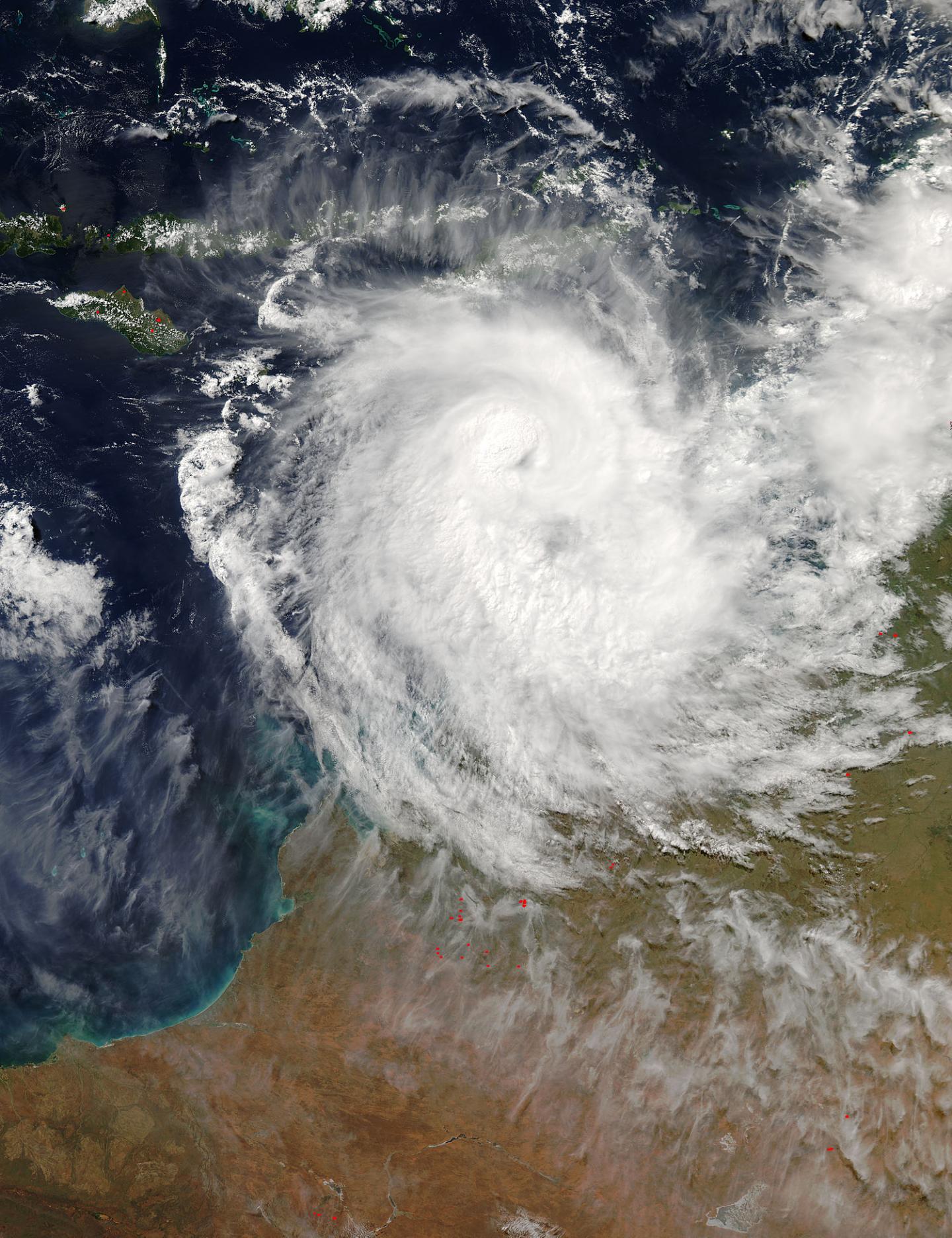
Two NASA satellites provided forecasters in Australia with visible and rainfall data as Tropical Cyclone Frances strengthened in the western Timor Sea. NASA's Aqua satellite captured a visible image of the storm that showed a cloud-filled eye, while the Global Precipitation Measurement Mission or GPM core satellite found heaving rainfall occurring.

Tropical cyclone Frances formed north of Melville Island, Australia on April 27, 2017. Frances has been gradually intensifying while moving south-southwestward through the Timor Sea. Frances had maximum sustained winds estimated at 50 knots (57.5 mph) when the GPM core Observatory flew over on April 27, 2017 at 1936 UTC. The rainfall analysis shown here used data collected by GPM's Microwave Imager (GMI) and Dual-Frequency Precipitation Radar (DPR) instruments. DPR data indicated that strong convective storms near the center of the tropical storm were dropping rain at a rate of over 70 mm (2.8 inches) per hour.

A 3-D examination of tropical cyclone Frances' rainfall structure was constructed using GPM's Radar (DPR Ku Band). It showed that the tops of convective storm towers near Frances' center were reaching heights of over 15 km (9.3 miles). GPM is a joint mission between NASA and the Japanese space agency JAXA.

On April 27, the Australian Bureau of Meteorology or ABM issued a Blue Alert for residents between Kuri Bay and Kalumburu, Western Australia.

On April 28 at 1500 UTC (11 a.m. EDT), the Joint Typhoon Warning Center or JTWC noted that Tropical Cyclone Frances reached hurricane strength with maximum sustained winds near 80.5 mph (70 knots/129.6 kph). It was centered about 347 nautical miles west of Darwin, Australia near 12.1 degrees south latitude and 125.0 degrees east longitude. Frances was moving to the west-southwest at 5.9 knots (6.8 mph/11 kph).

The Australian Bureau of Meteorology noted "Tropical Cyclone Frances is expected to continue moving southwest from the Timor Sea into the Indian Ocean during Saturday before weakening on Sunday. The cyclone is expected to remain over water as it moves into the Indian Ocean, however if it takes a more southerly track peripheral gales may affect the northwest Kimberley coast during Saturday morning." As Frances moves in a westerly direction it is forecast to move parallel to the coast of Western Australia and remain some distance away from the coastline.

Frances is expected to stay over the open waters of the Timor Sea and then the Indian Ocean while moving west-southwestward parallel to the Australian coast. Francis is predicted to encounter increasing vertical wind shear that will cause dissipation in about five days.

For additional forecast updates from ABM, visit: http://www.bom.gov.au.

###

Media Contact

Rob Gutro
[email protected]
@NASAGoddard

http://www.nasa.gov/goddard

############

Story Source: Materials provided by Scienmag

Share12Tweet8Share2ShareShareShare2

Related Posts

Africa’s Tick Diversity and Emerging Pathogens Explored

Africa’s Tick Diversity and Emerging Pathogens Explored

November 15, 2025

Stress Responses of Defective Cartilage Under Compression

November 15, 2025

Breast Reconstruction: Patient Outcomes by Incision Technique

November 15, 2025

Enhancing Wheat Defense Against Septoria Tritici Blotch

November 15, 2025
Please login to join discussion

POPULAR NEWS

  • blank

    Stinkbug Leg Organ Hosts Symbiotic Fungi That Protect Eggs from Parasitic Wasps

    318 shares
    Share 127 Tweet 80
  • ESMO 2025: mRNA COVID Vaccines Enhance Efficacy of Cancer Immunotherapy

    210 shares
    Share 84 Tweet 53
  • New Research Unveils the Pathway for CEOs to Achieve Social Media Stardom

    201 shares
    Share 80 Tweet 50
  • New Study Suggests ALS and MS May Stem from Common Environmental Factor

    142 shares
    Share 57 Tweet 36

About

BIOENGINEER.ORG

We bring you the latest biotechnology news from best research centers and universities around the world. Check our website.

Follow us

Recent News

Africa’s Tick Diversity and Emerging Pathogens Explored

Stress Responses of Defective Cartilage Under Compression

Breast Reconstruction: Patient Outcomes by Incision Technique

Subscribe to Blog via Email

Enter your email address to subscribe to this blog and receive notifications of new posts by email.

Join 69 other subscribers
  • Contact Us

Bioengineer.org © Copyright 2023 All Rights Reserved.

Welcome Back!

Login to your account below

Forgotten Password?

Retrieve your password

Please enter your username or email address to reset your password.

Log In
No Result
View All Result
  • Homepages
    • Home Page 1
    • Home Page 2
  • News
  • National
  • Business
  • Health
  • Lifestyle
  • Science

Bioengineer.org © Copyright 2023 All Rights Reserved.