• HOME
  • NEWS
  • EXPLORE
    • CAREER
      • Companies
      • Jobs
    • EVENTS
    • iGEM
      • News
      • Team
    • PHOTOS
    • VIDEO
    • WIKI
  • BLOG
  • COMMUNITY
    • FACEBOOK
    • INSTAGRAM
    • TWITTER
Saturday, August 23, 2025
BIOENGINEER.ORG
No Result
View All Result
  • Login
  • HOME
  • NEWS
  • EXPLORE
    • CAREER
      • Companies
      • Jobs
        • Lecturer
        • PhD Studentship
        • Postdoc
        • Research Assistant
    • EVENTS
    • iGEM
      • News
      • Team
    • PHOTOS
    • VIDEO
    • WIKI
  • BLOG
  • COMMUNITY
    • FACEBOOK
    • INSTAGRAM
    • TWITTER
No Result
View All Result
Bioengineer.org
No Result
View All Result
Home NEWS Science News

NASA sees Tropical Cyclone Debbie approaching Queensland for landfall

Bioengineer by Bioengineer
March 27, 2017
in Science News
Reading Time: 2 mins read
0
Share on FacebookShare on TwitterShare on LinkedinShare on RedditShare on Telegram
IMAGE

Credit: Credits: NASA Goddard MODIS Rapid Response Team

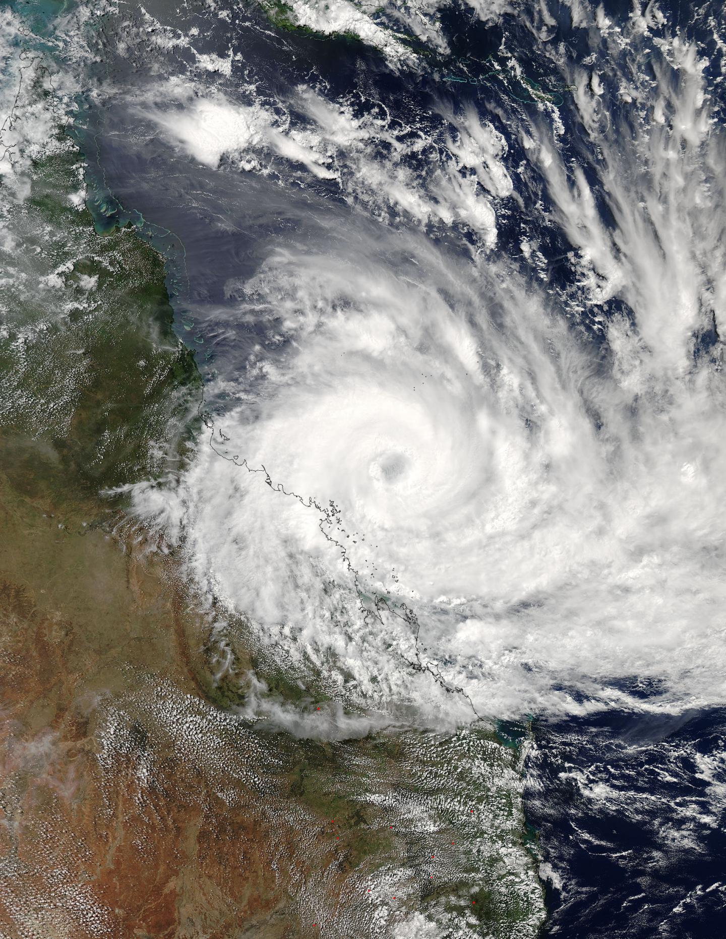
NASA's Aqua satellite passed over the storm early on March 27, 2017 as Tropical Cyclone Debbie had intensified into a powerful hurricane already affecting the coast of eastern Queensland, Australia.

The MODIS instrument aboard NASA's Aqua satellite captured a visible image of powerful Tropical Cyclone Debbie on March 27 at 0350 UTC (March 26 at 11:50 p.m. EST/1:50 p.m. AEST Queensland local time) as its eye approached the coast of eastern Queensland. Debbie's eye appeared cloud-filled and while still at sea, was almost parallel to Townsville.

The image showed powerful bands of thunderstorms wrapping around the low level center, and strongest storms in the western quadrant stretched along the coast from Townsville in the north, south to Mackay. The southernmost extent of the storm was near Bundaberg.

On March 27, the Australian Bureau of Meteorology or ABM warned "Severe tropical cyclone Debbie, category 4, continues moving towards the Whitsunday coast." The Australian categorization is equivalent to a Category 2 hurricane on the Saffir-Simpson Hurricane Wind Scale, which ranges from 96 to 110 mph (83 to 95 knots/154 to 177 kph).

NOAA's National Hurricane Center notes that a storm with this intensity has "extremely dangerous winds will cause extensive damage: Well-constructed frame homes could sustain major roof and siding damage. Many shallowly rooted trees will be snapped or uprooted and block numerous roads. Near-total power loss is expected with outages that could last from several days to weeks."

ABM's Warning Zone includes Lucinda to St Lawrence, including Townsville, Mackay, and the Whitsunday Islands, extending inland to Charters Towers, Mount Coolon, Moranbah, and Pentland.

At 11 a.m. EST on March 27 (or 1 a.m. AEST/Australia on March 28) Debbie's maximum sustained winds were near 175 kph (108.7 mph/ 94.5 knots). Debbie was centered near 19.8 degrees south latitude and 149.6 degrees east longitude. That's about 140 kilometers (87 miles) north-northeast of Mackay. Debbie was moving west-southwest at 8 kph (5 mph/4.3 knots).

ABM said "Severe tropical cyclone Debbie is currently a category 4 cyclone. It may intensify further as it continues to move west-southwest towards the Whitsunday coast this morning [March 28 AEST local time]. Severe tropical cyclone Debbie is forecast to make landfall between Ayr and Cape Hillsborough (north of Mackay) late this morning [March 28 AEST local time]."

###

For detailed forecasts about the warnings and what residents can expect for tides, storm surge, flooding, rain and winds, visit the ABM website: http://www.bom.gov.au/products/IDQ65002.shtml.

Media Contact

Rob Gutro
[email protected]
@NASAGoddard

http://www.nasa.gov/goddard

############

Story Source: Materials provided by Scienmag

Share12Tweet8Share2ShareShareShare2

Related Posts

blank

Weather’s Impact on Anopheles Mosquito Populations in Lagos

August 23, 2025
Ghost Spider’s Maternal Care vs. New Fly Species

Ghost Spider’s Maternal Care vs. New Fly Species

August 23, 2025

DWI-Guided vs. MRI-Based IMRT in Head & Neck

August 23, 2025

Uncovering Cutaneous SCC Genomic Diversity via Single-Cell DNA

August 23, 2025
Please login to join discussion

POPULAR NEWS

  • blank

    Molecules in Focus: Capturing the Timeless Dance of Particles

    141 shares
    Share 56 Tweet 35
  • New Drug Formulation Transforms Intravenous Treatments into Rapid Injections

    114 shares
    Share 46 Tweet 29
  • Neuropsychiatric Risks Linked to COVID-19 Revealed

    81 shares
    Share 32 Tweet 20
  • Modified DASH Diet Reduces Blood Sugar Levels in Adults with Type 2 Diabetes, Clinical Trial Finds

    60 shares
    Share 24 Tweet 15

About

We bring you the latest biotechnology news from best research centers and universities around the world. Check our website.

Follow us

Recent News

Weather’s Impact on Anopheles Mosquito Populations in Lagos

Ghost Spider’s Maternal Care vs. New Fly Species

DWI-Guided vs. MRI-Based IMRT in Head & Neck

  • Contact Us

Bioengineer.org © Copyright 2023 All Rights Reserved.

Welcome Back!

Login to your account below

Forgotten Password?

Retrieve your password

Please enter your username or email address to reset your password.

Log In
No Result
View All Result
  • Homepages
    • Home Page 1
    • Home Page 2
  • News
  • National
  • Business
  • Health
  • Lifestyle
  • Science

Bioengineer.org © Copyright 2023 All Rights Reserved.