A groundbreaking global review recently published in the Journal of Remote Sensing unveils the profound capabilities of satellite technology to monitor a quietly escalating phenomenon: the abandonment of cropland worldwide. This exhaustive study synthesizes over 250 scientific works, offering an unprecedented and nuanced understanding of how Earth’s farmland is increasingly being left fallow. By harnessing decades of satellite data and cutting-edge analytical techniques, the researchers have begun to decode the complex spatial and temporal patterns behind cropland abandonment, revealing implications that ripple through food security, ecosystem dynamics, and climate processes.
Satellite remote sensing has transformed the way scientists observe the planet’s surface, making it possible to track land use changes on immense scales with remarkable precision. Cropland abandonment — the process by which once-productive fields are no longer cultivated — constitutes a crucial yet under-explored component of land-use change. Traditionally overlooked in agricultural and ecological assessments, this phenomenon entails far-reaching consequences that extend beyond the loss of farmland into carbon cycling, biodiversity, and regional socioeconomic stability.
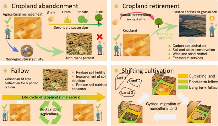
At the heart of this new study is the development of a sophisticated “cause–pattern–effect” framework, which connects satellite-detected land cover changes with their underlying socioeconomic drivers and resulting ecological outcomes. This multidimensional approach transcends mere mapping, illustrating how abandoned lands can either become refuges for biodiversity and carbon sinks or, conversely, exacerbate wildfire risk and pest proliferation. The review reveals that cropland abandonment is neither random nor uniform but follows discernible spatial patterns often linked to mountain regions, post-conflict zones, and areas hindered by poor infrastructure or economic decline.
.adsslot_uGKzoqTfQR{ width:728px !important; height:90px !important; }
@media (max-width:1199px) { .adsslot_uGKzoqTfQR{ width:468px !important; height:60px !important; } }
@media (max-width:767px) { .adsslot_uGKzoqTfQR{ width:320px !important; height:50px !important; } }
ADVERTISEMENT
The research team employed a suite of remote sensing tools to illuminate this complex phenomenon. Historical Landsat imagery enabled long-term trend analysis, while Moderate Resolution Imaging Spectroradiometer (MODIS) data provided insights into broad-scale agricultural dynamics. High-resolution satellite platforms, including China’s Gaofen (GF) constellation and France’s Satellite Pour l’Observation de la Terre (SPOT), offered the spatial detail necessary for identifying smaller, fragmented plots often overlooked in coarser datasets. Advanced machine learning algorithms, such as Support Vector Machines and random forests, raised detection accuracies beyond 89 percent, particularly when analyzing vegetation indices like NDVI (Normalized Difference Vegetation Index) over time-series data.
Importantly, the study underscores the challenges associated with defining and measuring cropland abandonment. Variations in terminology — seasonal versus permanent abandonment, active fallowing versus passive neglect — complicate comparisons across regions and studies. Satellites capture the spectral signatures of vegetation resurgence, but differentiating between temporary non-use and long-term abandonment demands integrated approaches that combine remote sensing with socioeconomic and field data. Researchers emphasize the need for standardized protocols to enable global monitoring consistency and robust policy applications.
Geographically, the review points to hotspots of abandonment with particular clarity. Eastern Europe stands out, where certain post-socialist regions exhibit abandonment rates upward of 27 percent, reflecting dramatic economic and land tenure shifts following political transitions. In Asia, China’s southwestern mountainous and arid zones emerge as contemporary hotspots. In Africa and Latin America, fluctuating agricultural practices and land reforms contribute to varying degrees of cropland disuse. These regional insights, derived from harmonized satellite datasets, provide policymakers with valuable indicators to anticipate food security risks and ecological shifts.
Ecologically, abandoned croplands are not simply lost assets; their rewilding offers complex trade-offs. In some cases, regenerative vegetation growth on fallow fields leads to increased carbon sequestration and habitat recovery, enhancing biodiversity. Conversely, unused farmland may become prone to invasive species, degrade soil quality, or become tinderboxes for wildfires under changing climate regimes. By integrating satellite observations with ecological models, the study outlines potential scenarios for the trajectory of abandoned land, framing these outcomes as critical considerations in future landscape management.
The study’s innovative “cause–pattern–effect” framework emerges as a dynamic tool for understanding cropland abandonment’s multifaceted nature. It synthesizes diverse data streams — from socio-economic indicators such as migration patterns, poverty levels, and dietary transitions, to high-resolution spatial data — to portray land abandonment as both a symptom and driver of deeper environmental and human transformations. This approach offers actionable insights for land-use planning, reforestation initiatives, and climate mitigation strategies, positioning satellite data at the nexus of science and policy.
Technological advances underpinning this research cannot be overstated. The inclusion of LiDAR (Light Detection and Ranging) offers three-dimensional vegetation structure information, enhancing the characterization of abandoned lands beyond mere spectral imagery. Cloud computing platforms like Google Earth Engine facilitate the processing of vast datasets, enabling real-time analysis and global assessments that were previously impossible. Combined with artificial intelligence techniques in image classification, these technological leaps are rapidly accelerating the monitoring of land-use changes essential to sustainable development.
Despite the progress, the authors advocate strongly for increased integration of remote sensing with ground-truth data and socioeconomic investigations. Remote sensing provides a bird’s-eye view but lacks the contextual sensitivity to capture drivers like policy shifts, cultural practices, or local economic conditions. As farmland abandonment accelerates in Africa and Asia, participative monitoring frameworks combining satellite data, field surveys, and community engagement will be critical to translating observations into effective interventions.
In the context of a warming planet, urban expansion, and shifting agricultural paradigms, understanding cropland abandonment carries urgent importance. This review lays a visionary foundation for future research and land management strategies that balance food production needs with ecosystem recovery and climate resilience. Through the lens of satellites, formerly invisible land changes are made visible, transforming how humanity perceives and responds to the silent transitions shaping rural landscapes worldwide.
Dr. Le Yu, the study’s corresponding author, encapsulates the research’s transformative potential: “Abandonment is more than empty land—it’s a signal of deeper transitions in how we live, farm, and interact with the environment. By pairing satellite data with ecological and social insights, we’re beginning to understand this hidden landscape. It’s both a warning sign and an opportunity.” Indeed, as the applications of remote sensing technology continue to evolve, the monitoring of cropland abandonment promises to become a key pillar in global efforts to achieve sustainable land use and environmental stewardship.
Subject of Research:
Not applicable
Article Title:
A Global Review of Monitoring Cropland Abandonment Using Remote Sensing: Temporal–Spatial Patterns, Causes, Ecological Effects, and Future Prospects
News Publication Date:
23-May-2025
Web References:
http://dx.doi.org/10.34133/remotesensing.0584
References:
10.34133/remotesensing.0584
Image Credits:
Journal of Remote Sensing
Keywords:
Artificial satellites
Tags: biodiversity loss from cropland abandonmentcarbon cycling and agricultural practicesecological consequences of land use changefood security and land abandonmentglobal agricultural trends and challengesimplications of abandoned farmlandinterdisciplinary approaches to land managementremote sensing technology advancementssatellite monitoring of cropland abandonmentsocioeconomic drivers of land abandonmentspatial patterns of land use changetemporal analysis of farmland abandonment


