The Antarctic region is particularly vulnerable to climate change, and studies have shown that the melting of Antarctic ice sheets has accelerated considerably in recent years. As a result, sea levels continue to rise globally, threatening the lives of coastal inhabitants.
Credit: The Authors, doi 10.1117/1.JRS.16.034514.
The Antarctic region is particularly vulnerable to climate change, and studies have shown that the melting of Antarctic ice sheets has accelerated considerably in recent years. As a result, sea levels continue to rise globally, threatening the lives of coastal inhabitants.
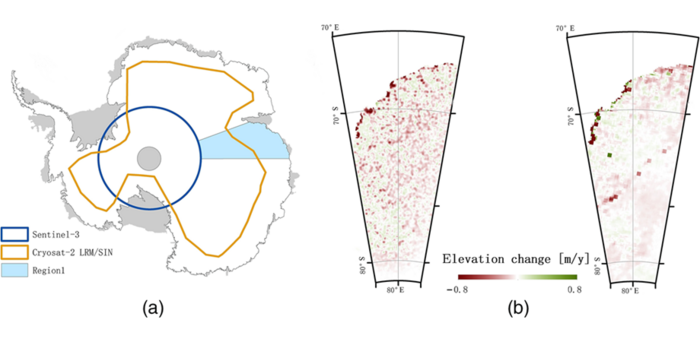
Given the potentially devastating effects of the melting ice sheets in Antarctica, scientists have been closely monitoring their topography and height for decades. This is usually done using satellites equipped with special altimeter radars, which provide a nearly continuous coverage of most of the Antarctic region. In many cases, data from multiple satellite missions are combined to achieve higher accuracy and precision as well as to compare data from different periods. However, combining these data is not a straightforward process because of the different instrumentation and processing techniques involved.
In a recent study, researchers led by Professor Jingjuan Liao from the Chinese Academy of Sciences tested a new approach that combined elevation data of the Antarctic ice sheet from two different satellites. As explained in their paper published in SPIE’s Journal of Applied Remote Sensing, their goal was to obtain a more accurate map of the latest elevation changes in the Antarctic ice sheet as well as validate their data analysis methods.
The data used in the study came from radar altimeters installed in CryoSat-2 and Sentinel-3, and corresponded to surface elevation changes in the ice sheet between 2016 and 2019. CryoSat-2, which was launched in 2010, provides greater coverage of the Antarctic ice sheet and has better accuracy in complex edge regions of ice sheets. In contrast, Sentinel-3, launched in 2016, offers higher resolution under most conditions and performs better in large flat areas.
To improve the accuracy of the results, the team first filtered the data using a clustering algorithm. Essentially, the algorithm divided up the input data points into clusters according to their value and rejected clusters containing outliers (which likely represented large measurement errors).
Additionally, the team employed a fitting model designed to extract elevation changes from the combined satellite data while correcting for measurement biases. To validate the results of this model, they compared them with reliable elevation data gathered using other altimeters.
Their analyses showed that the average elevation of the ice sheets had decreased at a rate of 4.3 ± 0.9 cm/year during 2016-2019. However, the inner continental ice sheet, where the terrain is mostly flat, had shown a milder decrease of only 1.1 ± 0.3 cm per year. “We derived a correlation between elevation changes and the surface slope, with rapid elevation changes occurring more often in areas with large terrain undulations, such as mountainous and marginal ice shelves,” Liao said.
With these results, the researchers are hopeful that their approach would find applications in future investigations of Antarctic ice sheets. “Our study presents an effective method for improving the measurement accuracy by combining elevation information from new radar altimeters. This could enable a long-term monitoring of global climate change in the Antarctic region,” Liao said.
Continued efforts on this front could help mitigate the adverse effects of global warming in the poles.
Read the Gold Open Access article by S. Li, J. Liao, and L. Zhang, “Extraction and analysis of elevation changes in Antarctic ice sheet from CryoSat-2 and Sentinel-3 radar altimeters,” J. Applied Remote Sensing 16(3) 034514 (2022), doi 10.1117/1.JRS.16.034514.
Journal
Journal of Applied Remote Sensing
DOI
10.1117/1.JRS.16.034514
Article Title
Extraction and analysis of elevation changes in Antarctic ice sheet from CryoSat-2 and Sentinel-3 radar altimeters
Article Publication Date
2-Aug-2022


